Trail Walking Brantôme en Périgord - Brantôme en Périgord Randonnée 21 févr. 2021 à 14:09 - Photo

Brantôme en Périgord Randonnée 21 févr. 2021 à 14:09

 morgoth
morgoth

User

© OpenStreetMap contributors
Length
Length
15.3 km
Max alt
Max alt
176 m
Uphill gradient
Uphill gradient
328 m
Km-Effort
Km-Effort  
19.6 km
Min alt
Min alt
97 m
Downhill gradient
Downhill gradient
327 m
Boucle
Boucle
Yes
Creation date :
2023-04-05 16:02:48.311
Updated on :
2023-04-05 16:03:31.631

(1 Reviews)

Walking
Walking
4h27
Difficulty : Very difficult

Scan this QR Code to open this trail in the SityTrail application

FREE GPS app for hiking

Logo SityTrail SityTrail

IGN / Geographical institutes

Download SityTrail from the App Store Download SityTrail from Google Play

Logo SityTrail SityTrail Plus

The world is yours!

Download SityTrail from the App Store Download SityTrail from Google Play Download SityTrail on Huawei AppGallery

About

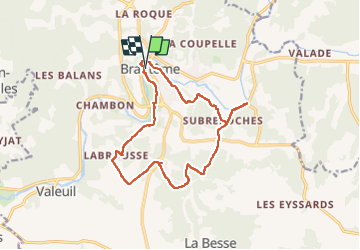
Trail Walking of 15.3 km to be discovered at New Aquitaine, Dordogne, Brantôme en Périgord. This trail is proposed by morgoth.

Description

Un des 4 circuits officiels proposés par la mairie de Brantôme-en-Périgord.
Vous pouvez trouver le PDF avec les points d'intérêt sur le site de la mairie ou de l'Office de Tourisme Périgord Dronne Belle (rubrique Téléchargements).

Elevation profile

Positioning

Country:
France
Region :
New Aquitaine
Department/Province :
Dordogne
Municipality :
Brantôme en Périgord
Location:
Unknown
Start:(UTM)
315804 ; 5025923 (31T) N.

Comments

Please log in to post a review or rate the element


Close
My subscriptions